বাংলা
 English
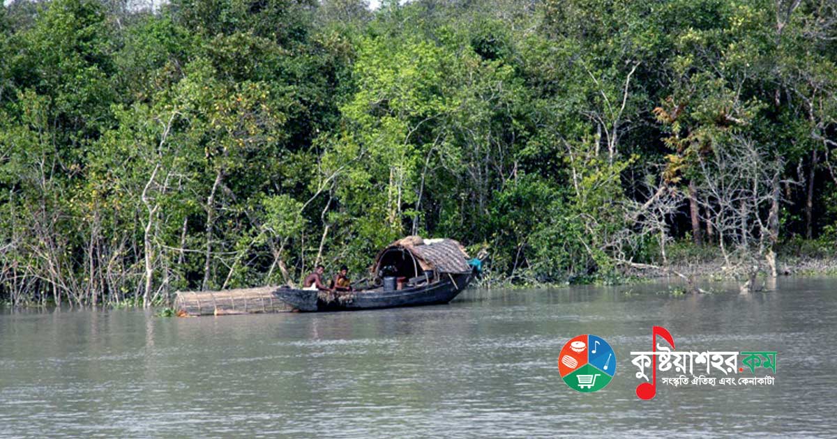
The Sundarbans is a vast forest situated in the coastal region of the Bay of Bengal and one of the natural wonders of the world. This beautiful forest, situated in the delta area of the basin of the three rivers the Ganges, the Meghna and the Brahmaputra, extends across the Khulna, Satkhira and Bagerhat districts of Bangladesh and the two districts of North 24 Parganas and South 24 Parganas of the Indian state of West Bengal. As the largest mangrove forest in the saline environment along the seacoast, the Sundarbans is the world's largest contiguous forest land.
Built over 10,000 square kilometers, 6,017 square kilometers of the Sundarbans lie in Bangladesh and the rest lies within India. The Sundarbans received recognition as a UNESCO World Heritage Site in 1997. Although the Bangladesh and Indian parts are in fact adjacent parts of the same uninterrupted landmass, they are listed under different names in UNESCO's World Heritage list; as 'Sundarbans' and 'Sundarbans National Park' respectively. The Sundarbans is entangled like a net with marine streams, mud chars and archipelagos of small size, including the salinity of mangrove forest land. 31.1 percent of the total forest land, that is 1,874 square kilometers, is watery area including rivers, khals and beels. The forest land, apart from the world-famous Royal Bengal Tiger, is known as the habitat of innumerable species of animals including various kinds of birds, spotted deer, crocodiles and snakes. According to survey, there are now 106 tigers and 100,000 to 150,000 spotted deer in the Sundarbans area.
On 21 May 1992 the Sundarbans received recognition as a Ramsar site. Thousands of tourists come to visit the Sundarbans every year. Countless tourists from home and abroad are charmed by the exquisite beauty of the Sundarbans. Through visiting the Sundarbans they gain various knowledge from its nature.
Naming
In Bengali the literal meaning of Sundarban is beautiful jungle or beautiful forest land. The Sundarbans may have been named after the sundari tree, which grows abundantly there. Other possible explanations could be that it was perhaps named from 'Samudra Ban' (sea forest) or 'Chandra-Bandhe (embankment)' (of ancient indigenous origin). However, it is generally assumed that the Sundarbans was named after the sundari tree itself.
History
During the Mughal period (1203-1538) a local king took the lease of the entire Sundarbans. Among the desired fundamental changes that took place in the historic legal changes is that it received recognition as the world's first mangrove forest and came under science-based supervision. Soon after the East India Company received proprietary rights from Mughal Emperor Alamgir II in 1757, a map of the Sundarbans area was prepared. The forest came under organizational management from around 1860, after the establishment of the Forest Department in the then Bengal province of India.
At the beginning of the eighteenth century the area of the Sundarbans was about twice the present size. Human pressure on the forest gradually compressed its area. In 1828 the British government acquired proprietary rights over the Sundarbans. L.T. Hajey conducted the first survey work of the Sundarbans in 1829. In 1878 the entire Sundarbans area was declared a reserved forest and in 1879 the responsibility of the entire Sundarbans was entrusted to the Forest Department. The name of the first divisional forest officer of the Sundarbans was M.U. Green. He performed the duty of divisional forest officer of the Sundarbans in 1884. At the time of the partition of India in 1947, 6,017 square kilometers of the Sundarbans fell within the Bangladesh part, which is about 4.2% of the area of Bangladesh and about 44% of the entire forest land.
The first legal right of the Forest Management Department over the Sundarbans was established in 1869. Under the Forest Act of 1965 (Section 8), a large portion of the Sundarbans was declared reserved forest land in 1875-76. Within the following year the remaining part too received recognition as reserved forest land. As a result it moved from the authority of the remote civilian district administration to the control of the Forest Department. Later, in 1879, the Forest Department was established as an administrative unit for forest management, whose head office was in Khulna. The first forest management plan for the Sundarbans was formulated during 1893-98.
In the water-adjacent basin of the Sundarbans there is a fair of breathing roots.
In 1911 the Sundarbans was described as a tract of waste land, which was neither ever surveyed nor ever came under enumeration. Then its boundary was demarcated over an area of about 165 miles (266 km) from the mouth of the Hooghly river to the mouth of the Meghna river. At the same time its inter-boundary was demarcated according to the three districts of the Twenty-four Parganas, Khulna and Bakerganj. The area of the entire region including water bodies was reckoned as 6,526 square miles (16,902 sq km). The watery beautiful forest was full of tigers and other wild animals. As a result the effort to survey it could not be very successful. The Sundarbans was most probably named after its principal special tree, the sundari (Heritiera fomes). The hard timber obtained from it is used in making boats, furniture and various other things. The Sundarbans everywhere is divided by rivers, khals and creeks, several of which served as waterways suitable for the movement of both steamers and local boats, for communication between Calcutta and the Brahmaputra basin.
Geographical formation
As one of the three largest mangrove forest areas in the whole world, the ecosystem of the Sundarbans situated in the Ganges basin is quite complex. The greater part (62%) of the Sundarbans, spreading across the two neighboring countries Bangladesh and India, is situated in the southwest of Bangladesh. To the south is the Bay of Bengal; to the east the Baleshwar river, and to the north a boundary along land of higher cultivation density. In the high areas, apart from the principal branches of the rivers, the other water channels everywhere are largely obstructed by embankments and low lands. In fact the Sundarbans was supposed to have an area of about 16,700 sq km (as reckoned 200 years ago). Diminishing, its present area has become equal to about one-third of the earlier one. At present the total land area is 4,143 sq km (including the 42 sq km area of sandbars) and the area of the remaining water channels including rivers, creeks and khals is 1,874 sq km. The rivers of the Sundarbans are the meeting place of saline water and fresh water. Therefore the intermediate place where the fresh water of the river coming from the Ganges turns into the saline water of the Bay of Bengal is this area. It extends across the Satkhira, Khulna, Bagerhat and Patuakhali regions of Bangladesh. The Sundarbans is situated in the southwest region of Bangladesh.
For a thousand years, along the Bay of Bengal, owing to intertidal flows, the Sundarbans has formed naturally through the accumulation of silt separated from the upland flow. Its geographical formation is deltaic, on whose surface there are innumerable water channels and beneath the water are scattered walls of soil and mud chars. It also contains marginal grasslands, sandbars and islands situated higher than the mean height of sea level, over which are entangled like a net khals, walls of underwater soil, primordial deltaic mud and accumulated silt. The height of the Sundarbans above sea level varies from place to place from 0.9 meters to 2.11 meters.
The biological elements play an important role here in the formation process of marine matters and in the field of faunal diversity. Diverse parts such as beaches, estuaries, permanent and temporary wetlands, mud chars, creeks, sand dunes and heaps of soil have been formed here. The mangrove plant world itself plays a role in forming new land. Again the intertidal plant world plays an important role in the morphological process in water. The presence of the mangrove animal world creates an individual morphological environment in the intertidal mud chars. It holds the silt in order to create a horizontal substratum for seeds. The organization and evolution process of the endless sand dunes is controlled by the abundantly present xerophytic and halophytic trees. Vines, grass and hogla stabilize the formation of the sand dunes and the unorganized silt strata.
Effects of climate change
The formation of the Sundarbans along the coast is influenced by multidimensional elements of nature, among which are the speed of the current, individual and collective current cycles and the currents of the long sea beach along the seacoast. The currents of the sea beach are quite variable in different seasons. They are also changed by cyclones.
The erosion and deposition that take place through these, although it has not yet been possible to measure them correctly, create quantitative differences in the change of the land's nature. Of course the mangrove forest itself plays a sufficient role in the stability of its entire system. In every monsoon rainy season the whole of the Bengali delta sinks under water, most of which remains submerged for about half the year. The silt of the lowlands of the basin comes primarily during the monsoon rainfall season, from the character of the sea and from events like cyclones. The biggest problem that the inhabitants living in the Ganges basin will have to face in the coming years is the increase in the height of the sea.
Owing to the change of the course of fresh water in the high region, the inflow of fresh water has decreased significantly in many of the Indian mangrove wetlands since the end of the 19th century. At the same time, owing to neo-tectonic movement, the Bengal Basin has also tilted slightly eastward, as a result of which the greater part of the fresh water is coming to the Sundarbans of the Bangladesh part. Consequently the amount of salinity in the Sundarbans of the Bangladesh part is much less compared with the Indian part. A research paper of 1990 stated that no evidence has been found that the deterioration of the natural environment of the Himalayas or the “green house” has increased the height of the sea and made Bangladesh's flood situation alarming. However, a UNESCO report of 2007 titled “Case Studies on Climate Change and World Heritage” stated that, along with the 45 cm rise in sea level caused by other man-made reasons, owing to further various man-made causes 75 percent of the Sundarbans could be destroyed (by the middle of the 21st century, according to the opinion of the Intergovernmental Panel published in the discussion on climate change).
Because there has not been enough initiative to save the mangrove forest that, along with the Sundarbans, stands as the natural wall of southern Bengal against marine storms, even the National Environment Court is worried.
Biosphere
In the Sundarbans the existence of two kinds of biosphere is seen: freshwater swamp forest and mangrove forest.
Freshwater swamp forest
The freshwater swamp forest of the Sundarbans belongs to the tropical moist-evergreen forests of Bangladesh. This kind of forest is an example of a saline-water swamp. The water of the freshwater biosphere is slightly saline and in the rainy season this salinity decreases somewhat, especially when the saline water is driven away by the water of the Ganges and Brahmaputra rivers and a thick layer of silt accumulates.
Floral diversity
Among the principal forest diversities of the Sundarbans are the abundant sundari (Heritiera fomes), gewa (Excoecaria agallocha), goran (Ceriops decandra) and keora (Sonneratia apetala). According to the reckoning of Prain published in 1903, there are altogether 245 classes and 334 species of plants there. After Prain's report, significant changes have taken place there in the various mangrove species and in their classification. Very little investigation has been done in forest nature to keep account of these changes. Although in most of the other mangroves of the world the classes Rhizophoraceae, Avicenneaceae or Laganculariaceae of trees predominate, in the mangroves of Bangladesh the classes Sterculiaceae and Euphorbiaceae predominate.
There is a large difference in the flow of plant life in the mangrove forest land of Bangladesh compared with other coastal mangrove forest lands that are not deltaic, and with highland forests. The importance of Rhizophoraceae is less compared with the former. The variation in the plant life cycle has been explained on the basis of the influence of pure water and low salinity in the northeast, and of water drainage and silt accumulation.
The Sundarbans has been classified as a moist tropical forest land, which has formed mainly in forest areas dominated by the keora (Sonneratia apetala) and other seacoast trees of the well-formed beach. Historically the Sundarbans has three principal kinds of plants, which have been identified on the basis of the depth of relation with the degree of salinity of the water, the degree of fresh water flow and the degree of the land's nature.
Across the region, along with the predominance of sundari and gewa, there are scattered dhundal (Xylocarpus granatum) and keora (Sonneratia apetala). Among grasses and shrubs, Poresia coaractata, Myriostachya wightiana, shon (Imperata cylindrical), nal khagra (Phragmites karka) and golpata (Nypa fruticans) are present in an organized way. The keora indicates newly formed silt land and this species is essential for wildlife, especially for the spotted deer (Axis axis). Along with the forest land, over a vast area of the Sundarbans there are saline and freshwater reservoirs, intertidal silt lands, sand chars, sand dunes, grasslands exposed on sandy soil and areas of trees and shrubs.
By succession is generally meant the sequential occupation of an area by various species of trees. On some growing mud char, the primordial species are gradually replaced step by step by new species arriving from outside. At last a local class of various species of trees suitable for that climate is created. According to Troup, succession generally begins in land formed from new silt. On this newly formed land the first sowing is of gewa, and along with it Avicennia and golpata. As the silt accumulates and the land grows higher, trees of other species come there. Among the latest arriving species, although the most familiar, is one - the gewa (Excoecaria agallocha). With the increase in height, on that land occasionally washed away by the current, the sundari (Heritiera fomes) next begins to come.
Faunal diversity
Extensive faunal diversity exists in the Sundarbans. Faunal diversity conservation management is confined within prohibiting hunting in certain areas of the Sundarbans, like sanctuaries where forest resources cannot be collected unconditionally and the life of wild animals is but little disturbed. Although it is evident that recently the faunal resources of Bangladesh have decreased, and the Sundarbans is not outside this. Even so, the Sundarbans has preserved quite a number of animal species and other species related to them. Of these, tigers and dolphins are being given predominance in planning faunal diversity conservation management and tourism development. The condition and conservation management of these two, in risky condition in a completely opposite environment, are strong indicators of overall faunal diversity and conservation management. According to the reckoning of 2004, the Sundarbans is the habitat of 500 Royal Bengal Tigers, which is the single largest portion of tigers in the world.
The ecosystem of the Sundarbans is of fundamental nature, and a vast habitat of wild animals. The influence of people's resource collection and forest management on the number of wild animals and their breeding grounds is great. Turtles (the keto turtle - Betagur baska, the sundi turtle - Lissemys punctata and the dhum soft-shell turtle - Trionyx hurum), monitor lizards (the Yellow monitor - Varanus flavescens and the Water monitor - Varanus salvator), the python (Python molurus) and the Royal Bengal Tiger (Panthera tigris tigris) are among the native species of the Sundarbans.
Some species among these are protected, especially under the Bangladesh Wildlife (Preservation) (Amendment) Act, 1974 (P.O. 23 of 1973). Some species, such as various species of deer (the Hog deer - Axis procinus and the Swamp deer - Cervus duvauceli), the buffalo (Bubalis bubalis), the Javan rhinoceros - Rhiniceros sondaicus and the Indian rhinoceros - Rhinoceros unicornis, and the freshwater crocodile (Crocodylus palustris), have become rare in the Sundarbans since the beginning of the 21st century.
Recent research has shown that the Sundarbans of Bangladesh, the repository of wonderful biodiversity, is commercially important: it is the habitat of 120 species of fish, 270 species of birds, 42 species of mammals, 35 species of reptiles and 8 amphibian species. From this it is understood that a large part of the various species exists in the Sundarbans of Bangladesh (for example, 30 percent of reptiles, 37 percent of birds and 37 percent of mammals) and a large part of them are rare in the other parts of the country. Of these wildlife, Sarker has noted that two amphibians, 14 reptiles, 25 aves and five mammals are presently endangered. According to the government, among this faunal diversity, 2 species of amphibians, 14 species of reptiles, 25 species of birds and 5 species of mammals are presently under threat. The Sundarbans is a paradise for ornithologists in the field of bird observation, study and research. Already many creatures have become extinct, among which are the wild buffalo, the para deer, the wild bull, the small and large one-horned rhinoceros, the bar shinga and the cheetah. More have vanished, various birds including the white manik pair-eared thuni, the bocha duck, the gogan ber and the marsh francolin.
The tigers of the Sundarbans
According to the reckoning of 2004, the Sundarbans is the habitat of about 500 Royal Bengal tigers, which is the single largest portion of tigers. These tigers are widely known because they kill a significant number of people, on average about 100 to 250 people every year. They are not the only tigers close to the boundaries of human habitation. In Bandhabgarh, fenced all around in the tigers' sanctuary, such attacks on people are rare. Owing to the various measures taken for security, not a single death from tiger attack has been reported in the Sundarbans of the Indian part. On the other hand, in the Sundarbans of Bangladesh, within the period from 1981 to 2004, more than half a hundred tigers died at the hands of people.
Local people and officially responsible persons take various security measures to prevent tiger attacks. Local fishermen perform prayers to the forest goddess Banbibi and observe religious rituals before beginning a journey. Praying for safe movement in the Sundarbans is also important to the local communities. Since the tiger always attacks from behind, fishermen and woodcutters wear masks on the back of the head. Although this measure works for a short time, later the tiger understands the trick and begins to attack again. Government officials wear hard pads like the pads of American football players, which cover the back part of the neck. This measure is taken to prevent the tiger's bite on the spine, which is their favorite attack technique.
Fish resources
No previous scientific research has been done on the overall fish of the Sundarbans. As a result, data-based information cannot be obtained about the present condition of the fish, the extinct fish and the endangered fish. Only those fish that people eat and those fish fit for export have been identified. It is thought that there are about 300 species of vertebrate fish in the Sundarbans. According to Sideinsticker and Hai (Perspective 1978), the commercial fish among them are of 120 species; however, according to Bernacsek (2000), commercial fish are of 84 species, crabs and shrimps of 12 species and snails of 9 species.
Fish resources in the Sundarbans are divided into two parts. All the fish together are white fish, the others are bagda, galda and crab. After the catching of shrimp fry began in the eighties, the abundance of fish suddenly decreased. At one time fish used to meet 80 percent of the local people's animal protein. Now the fortune of eating fish falls to the lot of very few people of the area. In the Sundarbans are found the kala shark, the ilsha kamot, the thuti kamot and the kanuya kamot. Before, they were found up to the Khalishpur area; now (2010) they have moved much farther south. Their presence is greater in the western Sundarbans. They have decreased greatly in number, especially the kala shark is hardly seen any more. Most of the 9 species of shankaj or shaplapata fish are now (2010) no longer seen in the creek areas of the Sundarbans.
The condition of the sea kuiccha and the dhani kuiccha, five species of the kuchhe-ka-kamila type of fish, is very bad. In the old days local people did not eat these fish, which look like the bam fish. Even now they do not eat them. But thousands of crab-catching fishermen use pieces of kuiccha fish as bait for catching crabs. In winter, in the wild khals of the seashore, at full tide in the almost clear water, the archer fish was once seen. These fish, of titputi fish size, seeing ants or various medium-sized insects on tree leaves or branches one to one and a half feet above the water, squirt intense water like a squirt gun, drenching the insect and dropping it into the water, and eat it. These fish grow to about a foot in length when adult. These fish are not seen nowadays. At one time the Java fish was heard of much; they grow 55 centimeters long. Now (2010) it is hard to find them. Very tasty fish like the payratoli or the chitra now fall very seldom into the fishermen's nets.
The most familiar fish of the Sundarbans is the parshe fish. This fish, up to 16 centimeters long, was once found in abundance everywhere in the jungle. Even now it is found, but very little. Of the parshe family too is the bata bhangan. Bhangan, gul bata and kharul bhangan are caught very little nowadays. The kharshula or khalla is an extremely tasty fish; they are hardly to be seen any more in the rivers and khals of the forest.
The kaikka or kaikshell fish of the Sundarbans is much larger in size than the freshwater kaikka. This thuti kaikshell of here is now (2010) caught very little. Two species of the huge-sized med fish are now on the verge of extinction.
Beside the spines of the deadly kan magur fish there is deadly poison. Although the large kan magur is still (2010) found somewhat, the dagi kan magur is now on the verge of extinction. Although some gulsha tangra and nona tangra of the tangra class are still found, the huge-sized shilong fish has almost become extinct. The kajli fish too does not suddenly catch the eye. The incomparably beautiful bhol fish. The koi bhol, the largest fish of the Sundarbans, is now caught but rarely. Before, the ugly-looking gongoinya fish was caught with hooks in the khals of the Sundarbans; now (2010) it is hardly found at all. The rekha fish was once seen quite a lot; nowadays it is not seen.
Although the guti datina is still (2010) found, the lal datina has become utterly rare. In the rivers and creeks of the Sundarbans at mid-ebb, the extremely tasty laksha fish (local name tariyal fish: Indian Salmon) raises a great stir, chasing about the small and medium parshe and datina fish. They grow to about four feet in length. Similarly the topshe fish (local name ramshosh) has faced scarcity (2010). Fishermen catch at least five species of chewa fish in the big rivers. Among these, the lal chewa has become endangered. The emblem fish of the Sundarbans and of all the tropical mangrove forests of the world is the meno fish (Mud Skipper), also known here and there as the dahuk fish. Five species of them are found in the forest. According to species they grow from 9 to 22 centimeters long.
Plenty of ilish is caught in the forest's Baleshwar and Kunga rivers. Of the two species of ilish, the chandana ilish is found less (2010). Of the 4 species of fasa fish, the ram fasa is found less (2010). The number of bairagi fish has also decreased. Inside the Sundarbans, in the medium-sized beels of the Poramahal, Andharmanik, Jongra and Shubdi-Gubdi areas, water is trapped in the rainy season; in places the tidal water enters. The water of these beels is sweet; sweet-water fish are found here. Mostly the jiol fish. Besides koi, shing, magur, two species of taki and shol, small tangra, puti, khalse, chela, darkina and various fish including small shrimps are found. Owing to global warming, saline water is entering these beels. The fish of these beels are therefore counting their last days.
At present (2010) fish are caught in the Sundarbans by 13 kinds of methods. Since the meshes of the push net and the rocket net are very small, fish fry and fish eggs are severely damaged. Owing to the fishermen in the Sundarbans area, fish resources are decreasing rapidly. But killing fish by poison causes the greatest damage.
Economy
The population of the Sundarbans is more than 4 million, but most of it is not permanent population.
Just as the Sundarbans has an important role in the economy of the southwest region of Bangladesh, so too it has an important role in the national economy. It is the single largest source of the country's forest resources. This forest supplies raw materials to industries dependent on timber. Besides, along with traditional forest resources such as timber, fuel and pulp, from this forest are regularly and extensively extracted leaves for thatching houses, honey, beeswax, fish, crabs and snails and shells. This land of the tree-rich Sundarbans is at the same time a necessary habitat, a producer of nutrition, a purifier of water, an accumulator of silt, a preventer of storms, a stabilizer of the coast, a repository of energy resources and a center of tourism.
This forest plays an abundant protective and productive role. The Sundarbans covers 51 percent of the protected forest area of Bangladesh, contributes about 41 percent of the total income from the forest, and contributes about 45 percent in timber and fuel production (FAO, 1995). Many industries (for example, newsprint, matches, hardboard, boats, furniture) are dependent on raw materials extracted from the Sundarbans. Various non-timber resources and forestry have created employment and income opportunities in significant measure for at least half a million coastal people. Along with the productive role, the Sundarbans plays a role as the natural security cordon of the coastal population of cyclone-prone Bangladesh and of their resources.
Despite being extensively used for human habitation and economic activity, nearly 70 percent of the forest land of the Sundarbans still survives; so reported the Overseas Development Administration (ODA) of the United Kingdom in 1985.
Between 1959 and 1983 the stock of forest resources decreased, mainly in the case of two mangrove species - the sundari (Heritiera fomes) and the gewa. The amounts of this decrease are 40 percent and 45 percent respectively (Forestal 1960 and ODA 1985). Moreover, despite the complete prohibition on hunting other wild animals except fish and some invertebrates, indications of a decrease in biodiversity are being found there (notable in this century are at least 6 species of mammals and 1 species of reptile) and consequently the quality of the ecosystem is decreasing (IUCN 1994).
Protected areas
National parks and sanctuaries of India
Sundarbans National Park
The Sundarbans National Park of West Bengal is composed of a national park, a tiger reserve and a biosphere reserve. It is situated in the western part of the Sundarbans, on the islands of the Ganges and adjacent to the Sundarbans belonging to Bangladesh. The delta area is covered by dense mangrove forest, and is one of the largest habitats of the Bengal Tiger. Here there are various species of birds and reptile species along with the saltwater crocodile. Presently the Sundarbans National Park was the core area of tiger preservation of the Sundarbans in 1973 and was declared a wildlife sanctuary in 1977. On 4 May 1984 it was declared a national park.
Sajnekhali Wildlife Sanctuary
The Sajnekhali Wildlife Sanctuary is a wildlife sanctuary situated at a place named Sajnekhali of the Sundarbans in the South 24 Parganas district of the Indian state of West Bengal. Its area is 362 sq km. In 1960 the West Bengal government declared it a sanctuary and in 1976 it was declared again.
Haliday Island Wildlife Sanctuary
The Haliday Island Wildlife Sanctuary is a wildlife sanctuary situated in the South 24 Parganas district of the Indian state of West Bengal. This sanctuary is situated over about 6 sq km of forest at the mouth of the Matla river near the Bay of Bengal. It was declared a sanctuary in 1976.
Lothian Island Wildlife Sanctuary
The Lothian Island Wildlife Sanctuary is a wildlife sanctuary situated in the South 24 Parganas district of the Indian state of West Bengal. This island is situated at the estuary of the Saptamukhi river near the Bay of Bengal. In 1948 this forest area was first notified as a sanctuary and in 1976 it was declared again. This sanctuary is a part of the Sundarbans delta.
Besides these national parks and sanctuaries, there are the Bharatpur Crocodile Project and the Sajnekhali Bird Sanctuary in the Indian Sundarbans.
Sanctuaries of Bangladesh
The area of the Bangladesh part of the Sundarbans is about 4,110 sq km. Of this, rivers, khals and creeks occupy about 1,700 sq km, whose breadth ranges from a few meters to a few km. Because of the net-like interconnected waterways, one can easily go by boat to almost every place of the Sundarbans. In charge of the management of the Sundarbans are 2 forest divisions, 4 administrative ranges - Chandpai, Sarankhola, Khulna and Burigoalini - and 16 forest stations. The forest is again divided into 55 compartments and 9 blocks. In 1993 the Khulna Forest Circle was newly formed for forest preservation and a Conservator post was created in it. The administrative head post of the Forest Department is Khulna-centered. For implementing necessary management and administrative decisions, under the divisional forest officer there are numerous professional, non-professional and supporting staff. The central unit of management is the compartment. The 55 compartments under the four forest ranges are divided precisely according to natural features such as rivers, khals and creeks.
In Bangladesh three sanctuaries were established in 1977 under the Bangladesh Wildlife Preservation Act, 1973 (P.O. 23 of 1973). They are:
- The East Sundarbans Sanctuary: area about 31,227 hectares. Along with the predominance of freshwater and of the sundari tree (Heritiera fomes), the gewa (Excoecaria agallocha), poshur and keora (Bruguiera gymnorrhiza) are present throughout the flood-prone area. The singra (Cynometra ramiflora) occurs in comparatively dry soil, the amur (Amoora cucullata) in water-dominated areas, the goran (Ceriops decandra) in saline areas and the golpata (Nypa fruticans) along the water channels.
- The South Sundarbans Sanctuary: spread over an area of 36,970 hectares. The area bears evidence of a vast seasonal variation in salinity. Among the principal tree species of the comparatively long-salinity-prone area is the gewa. It often grows in those places where the sundari cannot reproduce so successfully.
- The West Sundarbans Sanctuary: situated over an area of 71,502 hectares. On the comparatively dry land and river banks of this area grow the gewa, goran and hantal. In popular media the presence of the Sundarbans
- Most of the story of the award-winning anthropologist Amitav Ghosh's novel “The Hungry Tide” published in 2004 is centered on the Sundarbans.
- A part of the story of Salman Rushdie's Booker Prize-winning novel “Midnight's Children” is also centered on the Sundarbans.